Skip to content
DataMiner DoJo

More results...

Generic selectors
Exact matches only
Search in title
Search in content
Post Type Selectors
Search in posts
Search in pages
Search in posts
Search in pages
Log in
Menu
  • Blog
  • Questions
  • Learning
    • E-learning Courses
    • Empower Replay: Limited Edition
    • Tutorials
    • Open Classroom Training
    • Certification
      • DataMiner Fundamentals
      • DataMiner Configurator
      • DataMiner Automation
      • Scripts & Connectors Developer: HTTP Basics
      • Scripts & Connectors Developer: SNMP Basics
      • Visual Overview – Level 1
      • Verify a certificate
    • Video Library
    • Books We Like
    • >> Go to DataMiner Docs
  • Expert Center
    • Solutions & Use Cases
      • Solutions
      • Use Case Library
    • Markets & Industries
      • Media production
      • Government & defense
      • Content distribution
      • Service providers
      • Partners
      • OSS/BSS
    • DataMiner Insights
      • Security
      • System Architecture
      • DataMiner Releases & Updates
    • Agile
      • Agile Webspace
      • Everything Agile
        • The Agile Manifesto
        • Best Practices
        • Retro Recipes
      • Methodologies
        • The Scrum Framework
        • Kanban
        • Extreme Programming
      • Roles
        • The Product Owner
        • The Agile Coach
        • The Quality & UX Coach (QX)
    • DataMiner DevOps Professional Program
  • Downloads
  • More
    • Feature Suggestions
    • Climb the leaderboard!
    • Swag Shop
    • Contact
      • General Inquiries
      • DataMiner DevOps Support
      • Commercial Requests
    • Global Feedback Survey
  • PARTNERS
    • All Partners
    • Technology Partners
    • Strategic Partner Program
    • Deal Registration
  • >> Go to dataminer.services

Does Maps/Cube supports Geometry data?

Solved1.78K views18th July 2023coordinates Geometry Google Maps maps Open Street Maps
0
Arturo Lizcano [SLC] [DevOps Member]385 13th April 2021 0 Comments

Hi everyone,

Context:

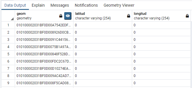
We are implementing a connector to geolocate some subscribers on a map based on the data stored in PostgreSQL. To achieve that, we could use the latitude and longitude (at this moment, they are empty) of each entry as well as a Geometry datatype:
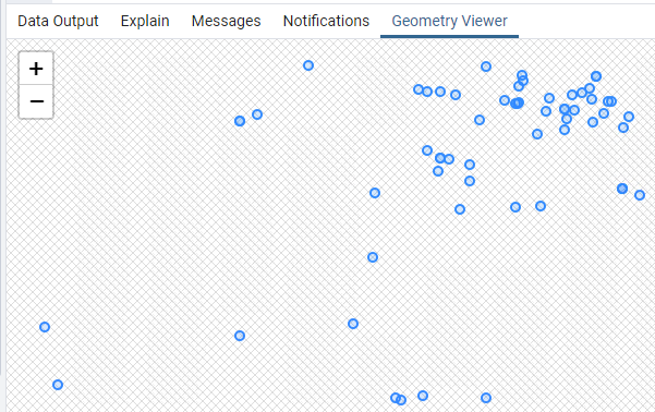
If a user clicks in the "Eye," all the points are automatically located in an empty canvas:

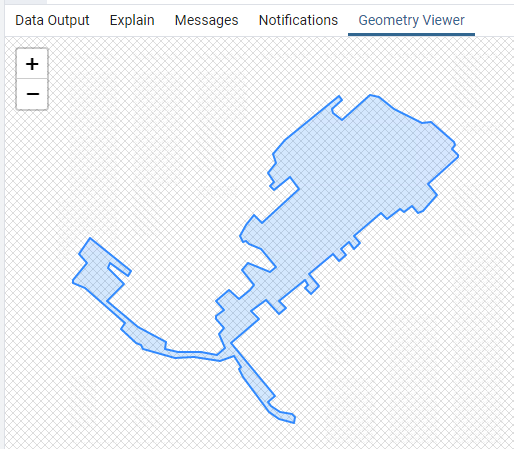
In other tables, we have the Coverage of some devices, stored again as geometry, but in this case, it is a polygon:

:

The geometry data type is used because it is supposed to be much nicer on the system resources than to load the coordinates one by one or load KML on a map.

Question time:

Are the Maps engines that DataMiner Cube supports able to use this type of data? If so, where could we find more information about it?

Marieke Goethals [SLC] [DevOps Catalyst] Selected answer as best 18th July 2023

2 Answers

  • Active
  • Voted
  • Newest
  • Oldest
1
Wim Bruynooghe [SLC] [DevOps Advocate]6.59K Posted 14th April 2021 0 Comments

DataMiner Maps makes use of data that is available in DataMiner, like a parameter table, element parameters, element properties, or even a table stored in a database of DataMiner (db.xml). If that's the case, then it's possible to display this data on a map as markers or as (poly-)lines. See the Help for more information.

Marieke Goethals [SLC] [DevOps Catalyst] Selected answer as best 18th July 2023
0
Michiel Vanthuyne [SLC] [DevOps Enabler]4.10K Posted 16th April 2021 0 Comments

Hi Arturo,

Something similar can be achieved using an overlay layer with kml or geojson info. However, in that case the geometries need to be available from an publicly accessible URL to allow the maps service such as Google Maps to access the data. See layer types in the help for more information.

Michiel Vanthuyne [SLC] [DevOps Enabler] Answered question 16th April 2021
Please login to be able to comment or post an answer.

My DevOps rank

DevOps Members get more insights on their profile page.

My user earnings

0 Dojo credits

Spend your credits in our swag shop.

0 Reputation points

Boost your reputation, climb the leaderboard.

Promo banner DataMiner DevOps Professiona Program
DataMiner Integration Studio (DIS)
Empower Katas

Recent questions

Invoke HTTP Session from QAction 1 Answer | 1 Vote
Masked alarmes permission management 0 Answers | 0 Votes
Remove all Widgets from Section 2 Answers | 5 Votes

Question Tags

adl2099 (115) alarm (62) Alarm Console (82) alarms (100) alarm template (83) Automation (223) automation scipt (111) Automation script (167) backup (71) Cassandra (180) Connector (109) Correlation (69) Correlation rule (52) Cube (151) Dashboard (194) Dashboards (188) database (83) DataMiner Cube (57) DIS (81) DMS (71) DOM (140) driver (65) DVE (56) Elastic (83) Elasticsearch (115) elements (80) Failover (104) GQI (159) HTTP (76) IDP (74) LCA (152) low code app (166) low code apps (93) lowcodeapps (75) MySQL (53) protocol (203) QAction (83) security (88) SNMP (86) SRM (337) table (54) trending (87) upgrade (62) Visio (539) Visual Overview (345)
Privacy Policy • Terms & Conditions • Contact

© 2025 Skyline Communications. All rights reserved.

DOJO Q&A widget

Can't find what you need?

? Explore the Q&A DataMiner Docs

[ Placeholder content for popup link ] WordPress Download Manager - Best Download Management Plugin