Skip to content
DataMiner Dojo

More results...

Generic selectors
Exact matches only
Search in title
Search in content
Post Type Selectors
Search in posts
Search in pages
Search in posts
Search in pages
Log in
Menu
  • Updates & Insights
  • Questions
  • Learning
    • E-learning Courses
    • Tutorials
    • Open Classroom Training
    • Certification
      • DataMiner Fundamentals
      • DataMiner Configurator
      • DataMiner Automation
      • Scripts & Connectors Developer: HTTP Basics
      • Scripts & Connectors Developer: SNMP Basics
      • Visual Overview – Level 1
      • Verify a certificate
    • YouTube Videos
    • Solutions & Use Cases
      • Solutions
      • Use Case Library
    • Agility
      • Learn more about Agile
        • Agile Webspace
        • Everything Agile
          • The Agile Manifesto
          • Best Practices
          • Retro Recipes
        • Methodologies
          • The Scrum Framework
          • Kanban
          • Extreme Programming
        • Roles
          • The Product Owner
          • The Agile Coach
          • The Quality & UX Coach (QX)
      • Book your Agile Fundamentals training
      • Book you Kanban workshop
    • >> Go to DataMiner Docs
  • DevOps
    • About the DevOps Program
    • Sign up for the DevOps Program
    • DataMiner DevOps Support
    • Feature Suggestions
  • Downloads
  • Swag Shop
  • PARTNERS
    • Business Partners
    • Technology Partners
  • Contact
    • Sales, Training & Certification
    • DataMiner Support
    • Global Feedback Survey
  • >> Go to dataminer.services

DataMiner Maps – Adding Filter Selection in the Maps

Solved88 views23rd September 2025Dataminer Maps maps maps configuration Visio
3
Jeeva Suria Rajah [SLC] [DevOps Enabler]1.74K 19th September 2025 0 Comments

Hi All,

I know we can add a filter box to DataMiner Maps, but do we have filter checkbox? Based on the documentation, I can see that we can filter by name and alarm severity. Is it possible to create filter checkbox based on a table column PID?

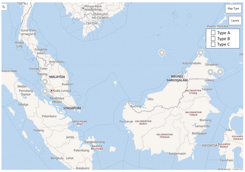
As you can see in the example below, I have several modems on the map, and they are of different types. Ideally, if I select a type, the modem markers should be filtered accordingly. The types are stored in the same table as the modem information, which includes Modem Name, Coordinates, and Type.

I'm currently using the Offline Map in the Visio.

Appreciate it if you could provide some feedback on how to achieve this.

Jeeva Suria Rajah [SLC] [DevOps Enabler] Selected answer as best 23rd September 2025

1 Answer

  • Active
  • Voted
  • Newest
  • Oldest
0
Wim Bruynooghe [SLC] [DevOps Advocate]6.65K Posted 22nd September 2025 0 Comments

If you know all the possible types, then in the configuration of the map (xml), you could add multiple layers for the same table, but each with a different table filter. Then the user can enable/disable layers as he wants.

To have more filtering capabilities, we recommend using the new Maps visualization in Dashboards and Low-code apps, as there you can make use of all the filter capabilities of GQI.

Jeeva Suria Rajah [SLC] [DevOps Enabler] Selected answer as best 23rd September 2025
Please login to be able to comment or post an answer.

My DevOps rank

DevOps Members get more insights on their profile page.

My user earnings

0 Dojo credits

Spend your credits in our swag shop.

0 Reputation points

Boost your reputation, climb the leaderboard.

Promo banner DataMiner DevOps Professiona Program
DataMiner Integration Studio (DIS)
Empower Katas
Privacy Policy • Terms & Conditions • Contact

© 2025 Skyline Communications. All rights reserved.

DOJO Q&A widget

Can't find what you need?

? Explore the Q&A DataMiner Docs

[ Placeholder content for popup link ] WordPress Download Manager - Best Download Management Plugin